Cool new features in Flickr!
 Have you heard of Flickr yet? No! Well listen up then: It's almost certainly the best online photo management and sharing application in the world! (No, nobody's paying me to say this, I just got outta bed with a lot of enthusiasm today). On the Flickr-blog 2 new features were recently announced:
Clustering, a better way to explore photos through tags, and Interestingness, a ranking algorithm based on user behavior around the photos.
With the clustering-feature, when exploring photos, you can now also root around finer distinctions. So 'dog nose red' will leave you with other hits then 'dog nose blue' (and they make sense too, try it out yourself)
But there's more to tell about Flickr. In order to get there though, firstly for something completely different: KML-documents. Google Earth KML Documents detail everything you need to know to create and share information with the Google Earth client. The simplest kind of KML documents are those that can be authored directly inside the client (Google Earth). That is, you don't need to edit or create any KML in a text editor. Placemarks, ground overlays, paths and polygons can all be authored directly in the Google Earth client! So that's cool, now back to Flickr >>

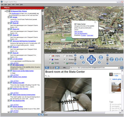
This guy at Geobloggers.com has created a so-called KML-network link so that after opening the file (which you can download here) Google Earth will open (so obviously you have to have Google Earth installed) it will enable you to see the 50 photos hosted on Flickr that are geospatially tagged as being closest to the center of your present viewpoint (so far 36,938 photos have been tagged)